The San Ramon Environmental Impact Report for the city center site states that the building FAR (Floor Area Ratio) is 1.27 FAR across the entire City Center project.
Make no mistake about this, this FAR is extremely dense.
Building Massing
Floor Area Ratio (FAR) provides a measurement of building massing and is calculated by divided project square footage (2,168,466) by the square footage of developable land area (1,702,760). The entire City Center project would have a 1.27 FAR, which is within the maximum allowable 1.35 FAR established in the Zoning Ordinance for the City Center Mixed Use (CCMU) zone. [DSEIR Section 4 Part Two - Aesthetics, Light, and Glare]
DSEIR FAR Report is Misleading
This however, is quite misleading because of the word "entire" is used to spread the FAR out over the entire 44 acre project. The lot with the three seven story office buildings is actually being proposed at a 2.0 FAR. Note: No other office developments in San Ramon come close to the building density being proposed in the City Center. All other business office buildings according to the General Plan are 0.45 FAR maximum.
Understanding FAR - Floor Area Ratio
Floor Area Ratio
From Wikipedia, the free encyclopedia
The Floor Area Ratio (FAR) or Floor Space Index (FSI) is the ratio of the total floor area of buildings on a certain location to the size of the land of that location, or the limit imposed on such a ratio.
The Floor Area Ratio is the total building square footage (building area) divided by the site size square footage (site area).
As a formula: Floor Area Ratio = (Total covered area on all floors of all buildings on a certain plot)/(Area of the plot)
Thus, an FSI of 2.0 would indicate that the total floor area of a building is two times the gross area of the plot on which it is constructed.
See Carfree Cities: FAR Explained
The current northern portion of undeveloped City-owned property where the three 7 story office buildings would be built is approximately 7.56 acres. The southern 6.71 acres portion contains parking areas associated with Bishop Ranch 1.
DSEIR 3.1.2 - Existing Conditions
The existing conditions of each individual parcel are described below. Photographs of the use of each parcel are shown in Exhibits 3-3a through 3-3e.
Parcel 1A
Parcel 1A consists of 14.27 acres of undeveloped land and developed parking areas associated with Bishop Ranch 1. The northern portion of Parcel 1A contains approximately 7.56 acres of undeveloped City-owned, rectangular-shaped property. This land contains ruderal vegetation, with ornamental landscaping surrounding the property on all four sides. This portion of the parcel contains fill imported from other nearby parcels that have been developed. The southern 6.71-acre portion of Parcel 1A contains parking areas associated with Bishop Ranch 1. The parking areas are characterized as at-grade, asphalt-paved with landscaped islands and freestanding lighting. Sidewalks are present along its frontages with Bollinger Canyon Road and the Bishop Ranch 1 East roadway.
Sunset Development has an existing entitlement to develop its portion of Parcel 1A as a 328,220-square-foot office complex in accordance with the previously approved Chevron Park Annexation and Development Agreement. This entitlement was originally granted to Chevron Corporation, the previous owner of the property. Sunset Development subsequently acquired the entitlement when it purchased the Bishop Ranch 1 property.
One acre = 43560 square feet. So, to come up with the square feet of the buildable area we can multiply the 7.56 acres X 43560 square feet = 329,313.6 square feet of land.
What is being purposed is for Alex Mehran of Sunset Development to build with the entitlement of 328,220 sq. ft. that originally came with the property, plus 194,652 sq ft. from the destruction of the office complex across the street, plus an additional 158,897 sq. ft. to come to a total of 681,769 sq. ft. of office space in the land mass of 329,314 sq. ft.
To figure the FAR, take 681,769 divided by 329,314 = 2.07 FAR.
This is Too Two FAR Out!
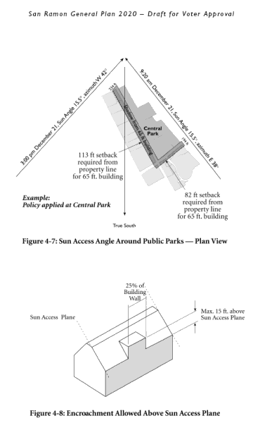
With these high structures next to the Iron Horse Trail, (note: the Iron Horse Trail is considered a regional trail and is maintained by the Parks District) they will tower above anything else in the city today. The DSEIR came up with shadow analysis on the Iron Horse Trail at 10 AM and 2 PM (where the sun is near it's peak heights) for both the summer and winter months, but conveniently left out the evaluation of what the shadows would be like at mid to late afternoon on the Iron Horse Trail. During the summer months, the Iron Horse Trail is used quite frequently in the mid to late afternoons. For this evaluation to be left out from the 600 page DSEIR is not by accident. This will have a significant impact on the Iron Horse Trail and needs to be taken into account properly, because technically the Iron Horse Trail is part of the Parks, according to the General Plan 4.8-I-17
"• Sun access planes adjacent to public parks (1:3.5) to prevent substantial shadow impacts.
City Center would be excluded from these requirements, with the exception of the sun access plane requirements adjacent to public parks. Refer to Figures 4-5 through 4-8."
The Iron Horse Trail is a regional trail facility that provides an excellent recreational experience for users. The Iron Horse Trail is operated and maintained by the East Bay Regional Park District (District). San Ramon City Article
What Does The San Ramon General Plan 2020 Say For FAR Averaging?
In the General Plan chapter 4 Land Use, Density/Intensity Standards it distinctly states, "No averaging is permitted such that the maximum FAR would be exceeded on any individual site." Well folks, this is exactly what is being done on the three seven (7) story office buildings site.
Here is the quoted text from the General Plan:
DENSITY/INTENSITY STANDARDS
The General Plan establishes density/intensity standards for each land use classification. In the residential designations, residential density is expressed as housing units per net acre, exclusive of public streets and other rights-of-way, drainage easements, public uses and undevelopable land (slopes over 20 percent and land subject to the Resource Conservation Overlay District).
For non-residential uses, a maximum permitted ratio of gross floor area to net site area (FAR) is specified. FAR is a broad measure of building bulk that controls both visual prominence and traffic generation, and is calculated exclusive of area devoted to parking. It can be clearly translated to a limit on building bulk in the Zoning Ordinance and is independent of the use occupying the building. No averaging is permitted such that the maximum FAR would be exceeded on any individual site. The Zoning Ordinance can provide specific exceptions to the FAR limitations for uses with low employment densities, or it can provide for bonuses in FAR in return for the provision of amenities for public benefit, such as workforce housing units. In addition to density/intensity standards, some land use classifications also stipulate allowable building types, such as single-family residential.
The density/intensity standards do not imply that development projects will be approved at the maximum density or intensity specified for each use. Zoning regulations consistent with General Plan policies and/or site conditions may reduce development potential within the stated ranges.
Let's call this for what it is, a Mega High-Density Center. The proponents of the Downtown City Center want to make you feel all nice and rosy with promises of a Downtown City Center with soul. What the people of San Ramon will get instead is a place that will bury their souls, and people will be asking years down the line, "Why on earth did the City Council want to place this high-density congestion on the people?"
Feel free to submit your articles. Please read the welcome message.


3 comments:
The Zoning Ordinance can provide specific exceptions to the FAR limitations for uses with low employment densities, or it can provide for bonuses in FAR in return for the provision of amenities for public benefit, such as workforce housing units.
Even though the zoning ordinance provides for exceptions, there still are limits placed on the FAR.
The General Plan does not allow for FAR averaging to be permitted. The City Center plan is in direct violation of the San Ramon 2020 General Plan.
San Ramon needs the city center to maintain economic viability as a mixed use city. The desire to work, live and play in the same community is strong within San Ramon. The Suburban life is an old trend that will not exist 100 years from now. Citys that do not move to provide a balance of economic and residential growth will loose out to those that do. There is no reason, why the well educated demographic of San Ramon should have to drive 40 miles to be economically productive in today's society. Let's move past the FAR. Let's think about the larger impact on the environment that a project like this will have for 50k residents. How many trips to walnut creek, dublin, san jose, and san francisco would be avoided with the downtown in place? Probably worth a little shade in the afternoon...
Post a Comment